A long time ago in a galaxy far, far away …
well from 1800-ish
(Ian Mackey, 2018)
Material primarily sourced from the historic environment record (HER) at our library The Hive (location map) and The Arboretum Story (Frederick Covins) – see the bibliography.
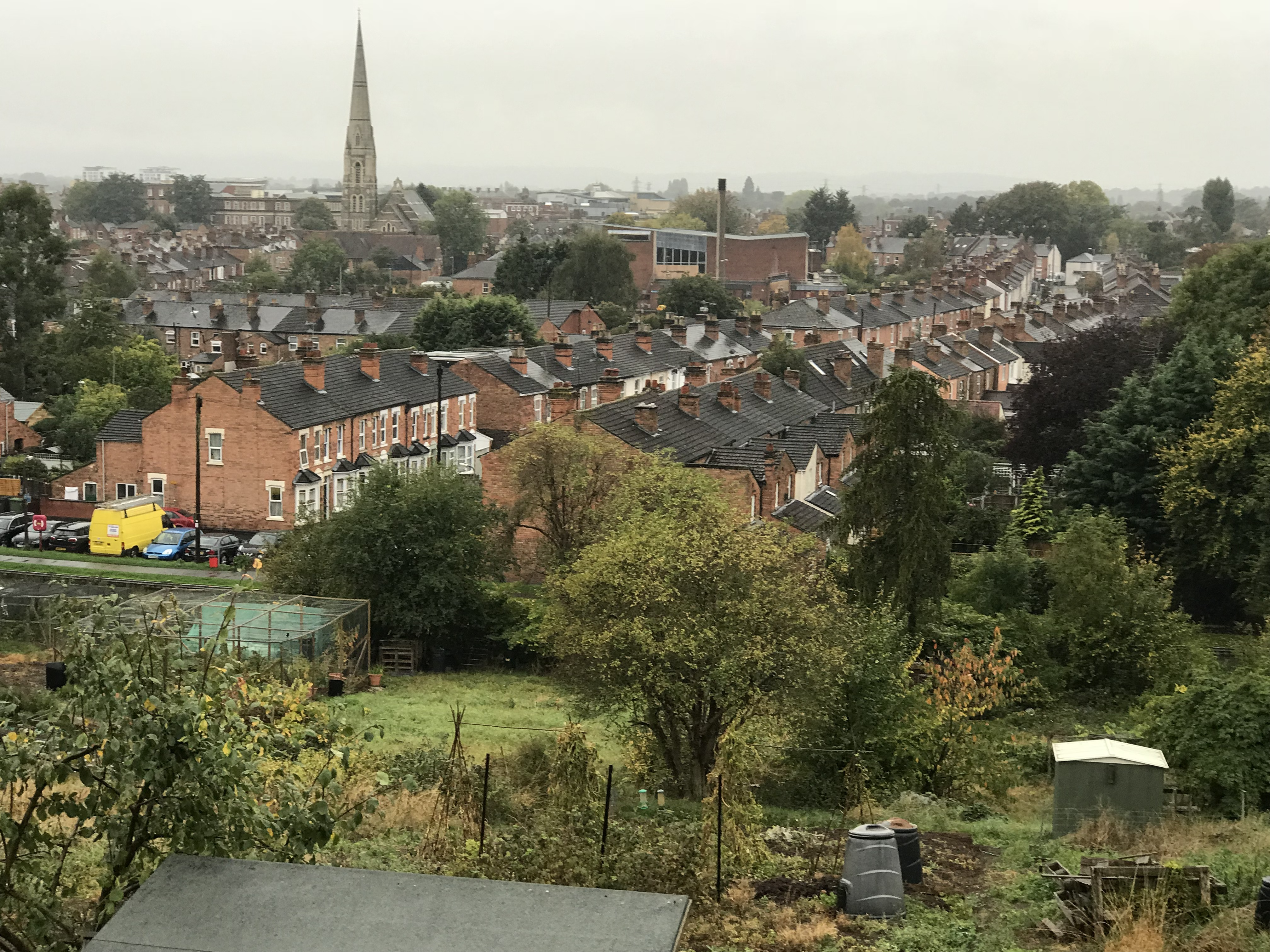
The Arboretum was originally grazing fields (Sansome Fields) on the outskirts of the small cottage-industry / market town, and was just by the city walls boundary in the parish of Claines. Not, by any stretch of the imagination, a well-to-do area, it was purely muddy fields in a valley. The valley had a garden allotment at the highest point on the hill to the East by Lansdowne Crescent – the area around the Bishop’s residence with his view of the Malvern Hills. Worcester News describes it well in the article “Days when The Arboretum really was an arboretum” (Worcester News, 2014).
Just to the East of the Medieval ‘linear settlement’ town of Worcester was the Tything where Ealdorman Æthelred and his wife Æthelfræd erected a church in the 9th century knows as St. Oswalds (St. Oswald and the Church of Worcester by J. Armitage Robinson) which is a listed building (Historic England list reference 1390235). Oswald had been sent away to become a monk, he was summoned back by his uncle (Oda) who died before his return.

A clear early impression copper engraved map with recent hand colouring
One part was dedicated to their arboretum famous for it’s Chestnut trees, on the other side of the communal walking path – closer to their residence, was a group of Tennis Courts.
Indeed, the Arboretum – as we know it know – was what was termed a “pleasure garden” for the good folk of Worcestershire Central.
The landowner hedged his bets when hearing rumours of this new industrial development coming along called a ‘canal’, so he partitioned up some of the land to sell it off in blocks.
This fitted in nicely with the Cadbury factory just North by Green Hill Lodge, not to mention the Garden House (on the corner of Sansome Walk and Arboretum Road).
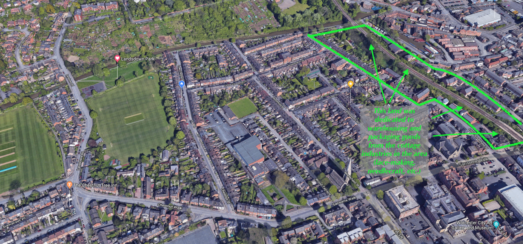
For an idea of the layout, have a look at this google map looking East with Sansome Walk running right-to-left (North), out of the city to the corner of the farmer’s fields (where the Chestnut Inn is) by what was then Sansome Fields (the area with the trees and houses just between Chestnut Walk and the RGS playing fields).
3-D Google maps of the Arboretum (the link with open a new browser window)
At that time, Chestnut Street did not exist as it was part of the Pleasure Garden, and the trees lining the Royal Grammar School (RGS) playing fields to the right (backing onto the houses of Lower Chestnut Street) shows a clear curvature which is where there was probably a droveway that went round the field and across the valley (now Wolverton Road and the houses at the North of Lower Chestnut Street by the canal).


The laundry next to the droveroad probably got its water from a well in the garden though there are no signs of it now.
Hangman’s Acre was last used in around 1675 where prisoners (one woman) were brought from the police station (located where the new one is just off Castle Hill) to be dispatched at dawn

(Google maps 2018 – looking East)
(Google maps 2018 – looking East)
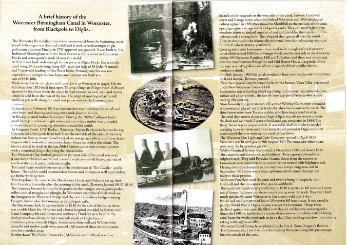
This canal being planned was to link the Bristol Channel with the thriving city of Birmingham, so at Diglis work started on the Worcester-Birmingham canal. It was like having a major A-road for lorries being built.
Diglis was chosen as it was the last most navigable part of the Severn River before it twisted its way north and besides, the Roman’s had trouble getting up there too which is why they built a quayside on the Severn before what is now the Worcester Bridge by the A44. They could have gone further north but the currents were too unpredictable leading to alluvial geomorphology which is why there is a “beach” by the racecourse Grandstand car park.
The landowners’ decision was to sell off part of the land to local developers and keep the Arboretum area as …the name suggests … and arboretum. It became a pleasure-ground for the well-heeled (better off folks having made money in their cottage industry of lace-making) to take a stroll out of town and picnic in the pleasure grounds by strolling along what was to become Sansome Walk.
Sir Aston Webb (an architect who designed the principal facade of Buckingham Palace and the main building of the Victoria and Albert Museum, among other major works around England, many of them in partnership with Edward Ingress Bell) designed the lovely St Georges Church of England Church at the end of St Georges Square.
These were affluent times for these folks as the development of the Arboretum was a pleasure-area that included the bowling club (which still exists today), statues and fountains and a bathing area (the site of the soon to be demolished swimming pool) just next to a Turkish bath

(Google maps 2018 – looking East)

One of the longest lasting areas was an ice-skating rink beside the bowling green.

(Google maps 2018 – looking East)
Westbury Pocket Park, Worcester.
The Oculus bridge, Worcester looking towards Westbury Pocket Park, designed by Charles Liddell.
Updated with a new planting initiative sponsored by the local city council
The Arboretum Residents Association (ARA) was awarded £12,800 by the Department for Communities and Local Government to revitalise Westbury Street Community Gardens, which is currently paved over with grey slabs.
Worcester News
And Worcester City Council is proposing to contribute up to £22,000 in its 2016/17 budget to further enhance the gardens.

(Alan Hitchcock – Feb. 2018)
So many parts of the Arboretum remain unchanged in design – thank goodness – so we live in a living, dynamic, friendly heritage enclosure …as the Sansome Fields were since the early 18th century.

(Philip Halling / The Arboretum / CC BY-SA 2.0 via WikimediaCommons)
There are a group of houses that we are looking at and they are linked to “Know Your Place” with Worcester City Council HER’s Worcester Life Stories.
As part of the Worcester Under Foot (WUF)… project, we have incredible donations and histories of the following locations:
- 10 East Street
- 2 Lower Chestnut Street
- 15 Lower Chestnut Street
Look at the local resources for you to be become part of and record the heritage of the Arboretum.
- The Hive, Worcester. UK
- The Arboretum Residents Association
- The Arboretum Story: A Social & Historical Record of the Arboretum Area of Central Worcester – Frederick Covins
- Worcesters fight for a railway and its consequences for the urban, commercial and industrial development of the city in the early Victorian period. – David J Cannings-Bushell, BA(Hons)
- Historic England
- John Speller’s Web Pages – GWR Narrow Gauge
- St. Oswald and the Church of Worcester by J. Armitage Robinson, D.D. (Fellow of The British Academy and Dean of Wells).
- Worcester News
Photos by
- Ian Mackey
- The Canal Festival (2015)
- Google maps
- Alan Hitchcock
- J.Roper engraving from a drawing by G.Cole

Excellent post however , I was wanting to know if you could write a litte more on this subject? I’d be very thankful if you could elaborate a little bit more. Thank you!
LikeLike
Thanks Galen (James)
We are working on writing more and have given talks on the Arboretum so will be adding more and consolidating what we have written and said to the goal of producing “The Arboretum Story ii” following on from Covins, F. (1989) The Arboretum Story. Arboretum Residents’ Association.
We are also doing podcasts (Look for CCAG on Spotify and Apple talks) and YouTube.com
LikeLike
It’s on it’s way. What else would you like to know?
LikeLike